The Far
East
Salimos de Rotorúa, camino a dar la vuelta a la península
del este de NZ. Según lo que nos habían informado, no habían muchos atractivos turísticos
ni cosas tan grandiosas para conocer, pero si íbamos a pasar por muchas playas
solitarias, con paisajes magníficos, pueblitos chicos sin mucho turismo, zonas
donde predominaba la cultura Maori… pintaba pleno para tomarnos unos días de
descanso y relajo … de disfrutar de las playas, sin mucho turismo.
Llegamos a Whakatane, primer destino del cabo este de la
Isla norte… nos aventuramos en hacer una caminata por una montaña que cruzaba
toda la costa, desde donde divisábamos islas… y se veía a lo lejos un volcán activo.
En total caminamos alrededor de 9 km… ya cansados.. intentamos llegar al
paradero de buses para regresar al estacionamiento donde habíamos dejado el
auto, pero llegamos 15 minutos tarde de la última salida de buses, menos mal
tuvimos suerte al tirar dedo, y unos muchachos nos regresaron al pueblo.

Knowing
that time for once is not a scarce resource, we took the route that at first
sight just seemed to be an interesting road, off the beaten track, no attractions
or highlights, just a road following 400 km of the forgotten Pacific Ocean
Highway along the Eastern Cape of the New Zealand North Island. After a bit of
research there seemed to be sites worth visiting for its natural, cultural or
historical value but the greatest asset seemed to be remote beaches, not many
people and good fishing grounds.
The trip
from Rotorua the coast took some first class navigation skills, as we got
caught up in forestation service roads well below the resolution of our map.
Guided by the sun, rail crossings, mayor landmarks and that slight mix of
nervousness and adventure, we made it to Whakatane, where a casual iSite (NZ
tourist information) visit turned into a late afternoon Coastal Walk with
beautiful bay and inland views and a casual glimpse of White Island. White
Island is NZs biggest active volcano and has been smoking since Captain Cook
first saw its summit. Interestingly, 2 attempts where made for sulphur mining
on the volcano the first one disastrously ending by 10 people being killed in a
lava flow, a second one because the growling and movement of the volcano warned
the workers they could meet a very similar faith. A few days after abandoning
the lava came down again. (Vacation blog ethics and correctness, oblige me to
site some Wikipedia research here).
NZ, el país de los kiwis … (y al decir de los kiwis, nos
referimos a los pájaros… no a la fruta) son muy difíciles de ver, son animales
nocturnos… ciegos… tienen alas pero sin músculo desarrollado por lo tanto no
pueden volar, han sido eliminados por depredadores como los oposum … ratas… y
actualmente hay reservas en algunos sectores, donde protegen a los kiwis, bueno…
teníamos una reserva de estas a media cuadra del camping donde nos estábamos quedando,
así que decidimos salir a hacer una caminata a la montaña, en la noche.. con
nuestras linternas a buscar kiwis, estuvimos desde las 10 pm como hasta la
media noche… y no logramos ver kiwis lamentablemente, pero si los escuchamos y
muy de cerca… pero seguramente se escondieron al escuchar nuestros pasos.
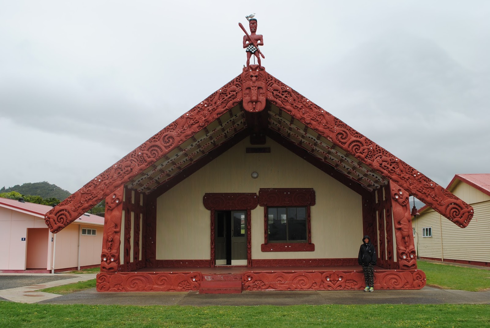

In pouring
rain, which lasted exactly half a day, we then headed east towards the Cape
crossing boundaries of several Maori tribes seeing there Marae (Ceremonial
gathering places), their mythical places and several witnesses of the local,
rather rural, Maori life style. A moment of silence and reflection came across
in front of a monument, on the Marae patio, commemorating the young people,
mostly Maori descendants because of their last names, who died in faraway
places contributing to the future and peace of Europe in 1939-1945. What, who
or which belief makes a 18 year old boy run away from its fishing grounds on a
peaceful coast to die in Gallipoli or the Ardennes? I could help an immense
feeling of senselessness and gratitude. I hope Europe will remember these boys.
Continuamos con el viaje, y pasamos por varios pueblos donde
predominaba la cultura Maori, pasamos por casitas donde tienen aún sus asambleas,
presenciamos como toda una familia al atardecer bajaban a la playa en busca de
erizos… o frutos marinos para cenar, estaban todos, padres e hijos caminando
entre las rocas una vez que había bajado un poco la marea… claramente Johan
aprovecho también en meterse un rato al agua, preguntar a los lugareños donde podía
pescar… y a la hora salió con su bolsita de 10 erizos... con los que hicimos un ceviche de erizos al llegar a nuestro hospedaje.


One of the
personal highlights of my Maori interaction was a swift discussion with 2
fisherman, diving for sea urchins, on the success of their dive and recommendations.
After some jokes about sharks, serious warnings about current and swell, some sharing
of better places to dive and some reluctant tips on the best place to dive, I
got into the water and after some struggling with the waves of the incoming
tide I came out with the ´promised sea urchins. I always knew that apart from
some Latin blood, there could be a few hints of Maori blood.
After
touching the most eastern point in the Southern hemisphere it was time to…head
west again. The land got a bit flatter and became more farming ground bringing
us to several of the beautiful bays on the Southern side of the cape with nice
sandy beaches, sandstone cliffs and remnants of a sheep farming and export
industry. Due to the remoteness, and poor road accessibility, all transport for
domestic or international market would go over sea, wharfs, freezing works,
shipping companies, rail roads made export of frozen sheep carcasses possible,
in some places like Tokomaru bay amounting to 400 vessels a year or a rough
calculation tells me about 40 sheep per hour. When returning WWII soldiers
started settling the area and building the necessary road infrastructure, sheep
were simply trucked out and today only shadows of a once flourishing industry
remain.


Los demás días en la costa este de la Isla Norte, los pasamos
en distintos camping, muy relajados… solo playa, lectura, caminatas por la
orilla del mar, caminatas por los muelles... salimos a dar un paseo en kayak …el
cual me costó bastante vencer el miedo antes de entrar al mar, ya que igual teníamos
algo de olas al inicio, y al primer intento vino una ola que me empapo entera y
lleno de agua mi kayak… me entro el pánico de pensar que la fuerza del agua iba
a darme vuelta el kayak en cualquier minuto… y Sali disparada… sin querer
entrar otra vez, pero unos minutos después me arme de valor otra vez, e intente
entrar ayudada por Johan … el sostenía mi kayak… hasta pasar la zona de olas… y
luego volvía a la orilla a tomar el suyo y empezar a remar alrededor del muelle…
entramos cerca de 2km y luego decidimos regresar al ver que ya empezaba a subir
la marea… todo iba bien, hasta que a unos metros de la orilla agarro una ola
que venía con una fuerza que me venció y termine dándome vuelta… con el kayak
encima… claramente me di el susto de la vida, pero no fue más que eso… un susto
que después se me fue al pisar tierra y llegar a la orilla donde ya me sentía a
salvo.


Beaches,
plenty of time to relax and read, some sea kayaking, walking in the footsteps
of Captain Cook and his crew when they first set foot on NZ soil and more
beaches took us around the Cape to the footsteps this time, 200 years after
Captain Cook, of my mum in Gisborne (at the time I didn’t know she did a dental
practice internship there) where we prepared for the next part of the trip,
some decent NZ native bushwalking.


No hay comentarios.:
Publicar un comentario